
St. Joseph Peninsula Beach Renourishment Project
November 21, 2019: Construction activities have officially finished and thus concludes the construction of the 2019 St. Joseph Peninsula Beach Renourishment Project. Additional videos highlighting project construction and the finished beach re-nourishment project can be found on MRD Associates, Inc. YouTube page found at the following link St. Joseph Peninsula Beach Renourishment Project Videos..
November 1, 2019: County Beach Project Completed! Construction activities finished this week as Manson Construction succesfully placed beach fill within the construction template over the project limits (South End of Rish Park to Stumphole.) Manson has begun cleaning the beach (rut removal) and removing their equipment. Additionally, as part of the contract and in compliance with our permits, they will be tilling the beach this coming Monday (11/4) from roughly R-100 (just north of the southern subline location) to the southern end of Rish Park. Please note, the tilling will make the sand extremely soft and it is advised not to drive on it immediately after the tilling has occured.
October 22, 2019: Project Update! Construction activities have resumed following Tropical Storm Nestor. Construction is currently progressing in Segment 3 heading south to tie into the northern portion of Segment 2, which ended roughly in the vicinity of Aruba Drive and Belize Drive (~R-97). Construction activities are currently in the vicinity of Haven Road (~R-94). Pending any unforeseen delays, the project is expected to wrap up sometime next week.
October 17, 2019: Project Update! Construction activities have been temporarily suspended due to the imminent effects of Potential Tropical Cyclone Sixteen. The dredge is currently underway to Panama City for a previously scheduled re-fueling and will remain there until weather conditions allow for safe passage back to the project site. Additionally, shore pipe and beach equipment are in the process of being secured. The current northern extent of the beach fill is at approximately R-97 (Aruba Drive). An updated completion date will be determined once post-storm assessments are made and construction begins again.
October 11, 2019: Schedule Update! Segment 2 is expected to be completed in the next couple of days. Construction is expected to continue northward from the current location (Cliffton Beach Drive, R-99) to approximately Cancun Drive (Between R-97 and R-96) and then stop. Construction activities will then commence near the northern subline in the vicinity of Seagrass Circle (R-93) and then proceed south (Segment 3) towards Cancun Drive to tie back into the northern part of Segment 2. In preparation of switching from the southern subline to the northern subline, mobilization and construction related activities will start in the next couple of days near the northern subline and beach access may be temporarily limited in that area. Additionally, the renourishment project is now expected to be completed on or around October 26th, 2019, subject to change pending any weather or other delays.
October 10, 2019: Progress Update & Project Videos! Segment 1 has completed and progress is being made on Segment 2 as of this morning. Segment 2 ends in the vicinity of R-97 if you reference the provided Construction Drawings below. The speed at which construction is being completed will pick up as the volume of sand being placed in the coming sections is less than the volume placed on the southern end of the project. Please see the map below for a relative location of the beach and dune placed to date and the current direction of the beach fill placement. Also, please remove any sand fencing prior to the fill being placed in front or your property.
Additionally, We have posted a collection of videos taken to date onto YouTube that highlight the progress of the project. We intend to update this video playlist overtime as construction progresses. The videos can be found here: St. Joseph Peninsula Beach Renourishment Project.

October 9, 2019: Boardwalk Locations in the Template! Please find below a link that provides a list of properties that should remove their boardwalks up to the dune line in order to recieve the maximum amount of sand. You may choose to leave your boardwalk/walkway in place, but it may either get buried or the contractor may elect to not fill underneath of it. If you have any questions, please feel free to reach out to us as via the contact link on this site and we will do our best to answer any questions we can as soon as possible.
October 4, 2019: Project Update! The project is well underway and the contractor is actively working in the phase 1 section. The figure below shows the relative locations of where the contractor has completed placing sand and in which direction they are actively pumping. Additionally, in the coming days, we will be reaching out to certain homeowners that are located within the phase 2 segment about their boardwalks that are located within the fill template. We anticipate accomplishing this next week by placing notes on any boardwalks that should be removed in order to get the maximum amount of sand possible in front of your property. Please note the contractor cannot place sand under your boardwalk and is not required to leave a stockpile. The project is currently on schedule and is expected to wrap up in 30 days depending on unforseen circumstances. Unfortunately, we cannot provide schedule estimates as to when the project will be located near your property or vacation rental. We do have a planned delay coming up in the near future as the dredge will have to take on fuel at a nearby harbor. More to come. Thanks!

September 18, 2019: Project Update! Mobilization is well underway at the moment and we are anticipating beginning the pumping of sand on September 23rd, subject to change from any unanticipated delays. We have also provided revised construction plans that have been updated as a result of the damages from Hurricane Michael and the continued background erosion along the Cape. You can find images of the plans here: 2019 Construction Drawings
September 11, 2019: Schedule Update! We are getting closer to beginning construction of The St. Joseph Peninsula Beach Renourishment and Environmental Enhancement Project. The Contractor is currently mobilizing to the site this week with equipment already on site. The dredge vessel is now expected to arrive sometime around September 23rd. Unfortunately, Hurricane Dorian had delayed the Dredge vessel's transit around the Florida Peninsula to the project site and has pushed the schedule back by approximately a week.
August 30, 2019: Schedule Update! The Contractor is mobilizing to the site in the next couple of days with the dredge vessel arriving sometime around September 13th, plus or minus several days. Hurricane Dorian has the potential to impact this schedule, but as of today, we are still moving forward with construction plans for the beach project. The phasing plan as described below remains the same at this time and more updates are to come.
August 9, 2019: Revised Schedule! Due to delays on another dredging job, Manson Construction has had to delay mobilization efforts to the Peninsula by approximately three weeks. At this point mobilization is expected to occur at the end of August, with sand pumping set to begin in the first or second week of September. Site assessment and project planning are still underway to kickoff this project in September!
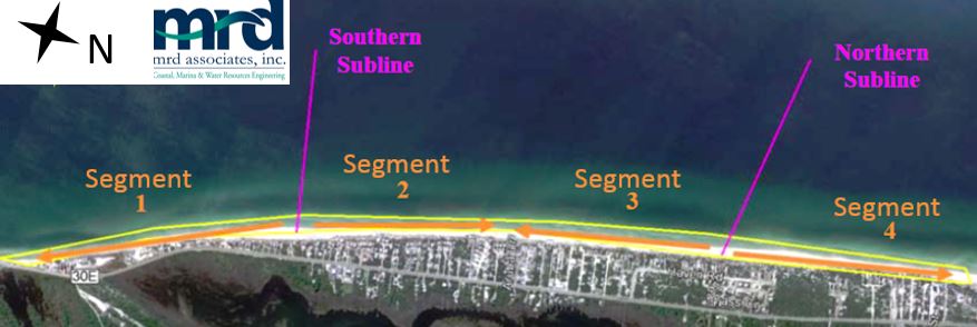
July 16, 2019: Schedule Update! Construction related activities for the St. Joseph Peninsula beach renourishment project are set to begin within the first week of August. The project limits include the area of beach between the Stumphole revetment and the southern boundary of Billy J. Rish Park. Mobilization efforts by the Contractor, Manson Construction Co., will be beginning shortly in anticipation of starting to pump sand around the third week of August. Sand pumping is set to begin in the area of the beach south of the Scallop Cove Convenience Store, and will progress southward initially. Staging and stockpiling of construction equipment will be occurring near the Stumphole revetment. The following image illustrates where the sand pumping will begin and the initial direction of construction. Project phasing is also briefly discussed below.

In general, the beach project will begin at the southern end of the project area and advance to the north toward Rish Park. There will be two “Sublines” (Southern and Northern) where pipes are connected to a hopper dredge anchored offshore, so that sand can be pumped directly onto the beach. Manson intends to use the Hopper Dredge GLENN EDWARDS for this project (link to vessel statistics). Pumping will begin on the beach in the area shown above just south of the Scallop Cove Convenience Store (“Southern Subline”) and will proceed to the south along Segment 1 toward the Stumphole revetment. Once Segment 1 is complete, the contractor will then proceed to the north from the “Southern Subline” along Segment 2. Upon completion of Segments 1 and 2, the contractor will move to the “Northern Subline” to fill Segment 3 and end with Segment 4. Please note, all schedules provided are tentative and subject to change.
April 12, 2019: Schedule Update! We are getting closer to restarting the St. Joseph Peninsula Beach Renourishment project. Manson Construction is still Gulf County's Contractor to construct the beach project and have provided us with an updated schedule. Our tentative schedule to begin construction and to begin pumping sand is slated for the end of August 2019, with mobilization and staging beginning approximately two weeks prior to that date. We will be posting more information in the future as it becomes available for public release. In the meantime, please feel free to browse through the FAQ's for any project related questions and for any additional questions not answered in the FAQ's, feel free to contact us through the email form below.
January 17, 2019: Status Update! We have been working behind the scenes to get the project back up and running since Hurricane Michael's landfall. The beach renourishment project is tentatively slated to begin construction in late spring/ early summer time of 2019. We are still assessing the post-storm beach conditions and are beginning to re-design the project to account for changes to the beach as a result of the Hurricane. As more information becomes available, we will be sure to update this site more frequently.
October 16, 2018: Due to the recovery efforts in Gulf County associated with the Category 4, Hurricane Michael, the start of the proposed beach renourishment project has been delayed until further notice. We will continue to post updates on the project status as they become available to be released to the general public. We will continue to work with the County on the restoration of the St. Joseph Peninsula beaches.
October 8, 2018:Project Schedule Update! The Project is temporarily delayed due to the arrival of Hurricane Michael this week. We are estimating starting the project around the end of this week at this time. An update will be provided once we assess the beach conditions after Michael passes.
October 1, 2018: Project Schedule Update! The Project is still set to begin on October 8th south of the Scallop Cove convenience store. The following image illustrates where the pumping will begin and the direction. Manson Construction has mobilized to the Peninsula and is making the necessary preperations to begin pumping sand this coming Monday. At this time, it is unknown if we will have a full project or not. Further updates will be provided as we confirm more information. Thanks for your patience to date!

September 24, 2018: Project Schedule Update! In response to the special BCC meeting last Monday, the project is tentatively set to begin on or around the week of October 8th, 2018 with reduced project limits due to the reduction in funding (RESTORE Act Grant.) The contractor, Manson Construction Co. will begin to mobilize to the site in the next couple of days near the Stumphole rock revetment. Following the completion of mobilization efforts, sand will begin being pumped from an area south of Scallop Cove from a contractor installed subline, and will progress southward. Depending on the award of a grant from the RESTORE Act, the project will either end near the rock revetment or then proceed to the north towards Billy J. Rish Park. Additional project related details to be provided soon. Please visit the FAQ's for questions commonly asked relating to construction of the beach project such as what to do about your boardwalk.
August 3, 2018: The Frequently Asked Questions (FAQ's) have been updated to add additional information on what visitors and homeowners can expect while the project is under construction. Also included are links to articles published with an update on the status of the project from Gulf County.
July 31, 2018: We currently do not have an anticipated start date at this time. An update on this website will be provided once we have the final details in order.
June 15, 2018: Manson Construction Co. was awarded Bid No. 1718-13 for a total of $10.2 Million to place roughly 705,000 Cubic Yards of sand on the southern end of St. Joseph Peninsula. The Contractor intends to start in the vicinity of the Stumphole revetment and progress northward. Construction is estimated to begin on or around August 1, 2018, subject to change.
March 19, 2018: Plans and Specifications have been released to potential bidders for the 2018 St. Joseph Peninsula Beach Renourishment Project - Rebid, Bid Number: 1718-13. BIDs will be received until 4:00 p.m., Eastern Daylight Time (EDT), on Monday, April 23, 2018 at the office of the Clerk of Circuit Court, 1000 Cecil G. Costin, Sr. Boulevard, Room 148, Port St. Joe, Florida 32456.
January 25, 2018: MRD Associates, Inc. made a presentation to the Gulf County Board of County Commissioners (BCC) on January 23, 2018 regarding the upcoming beach re-nourishment project. Based on the recommendations made by MRD Associates, Inc., the BCC approved the re-bidding of the St. Joseph Peninsula Beach Re-nourishment Project. The presentation made to the BCC including recommendations can be found below in PDF format.
November 15, 2017: As of today, we do not have an anticipated start date for the beach renourishment project due to the recent bid submittals. We are actively working with the County to assess all options. When further information is available, we will publish it via this website. Please check the website periodically for further updates regarding the project.
History and Background
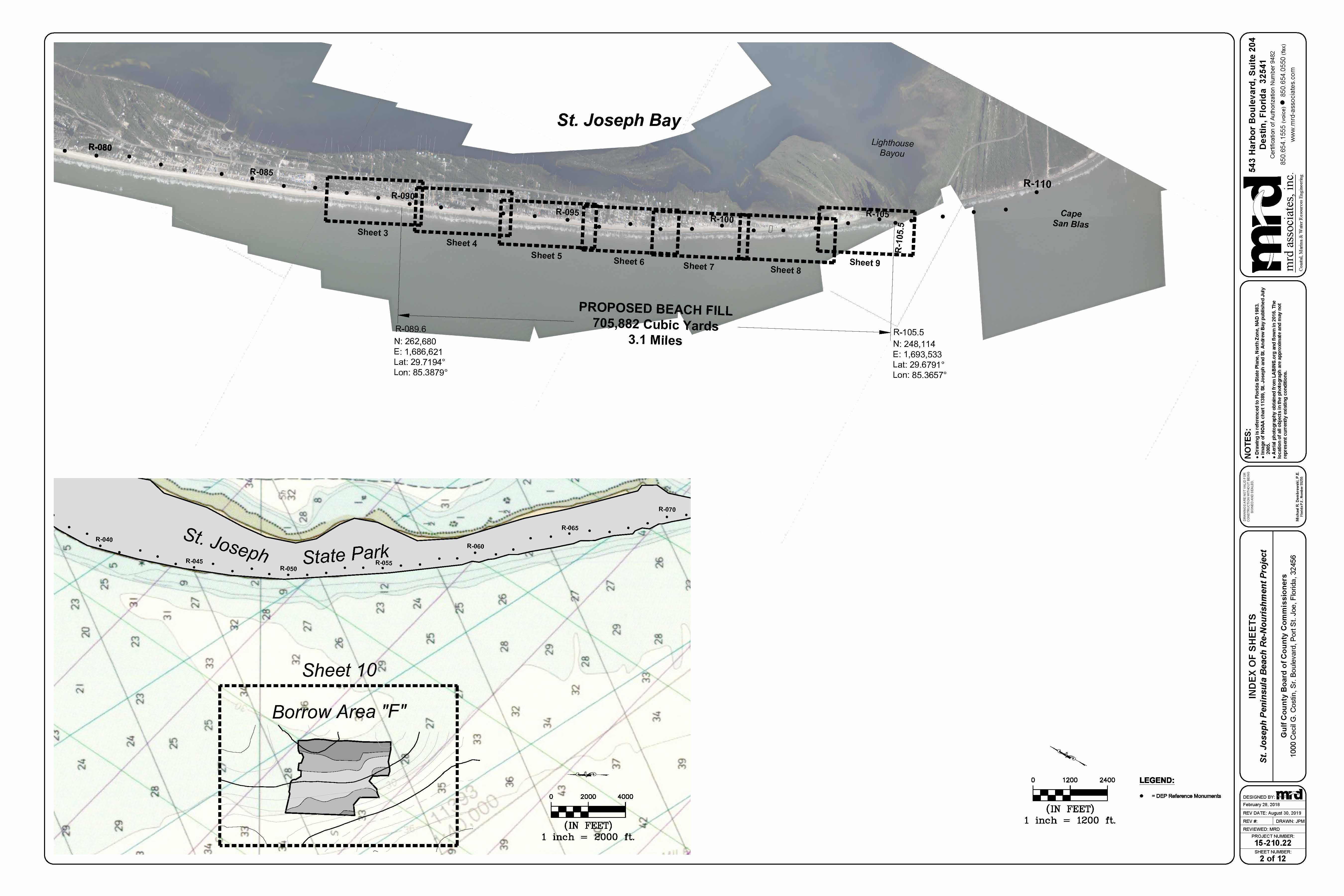
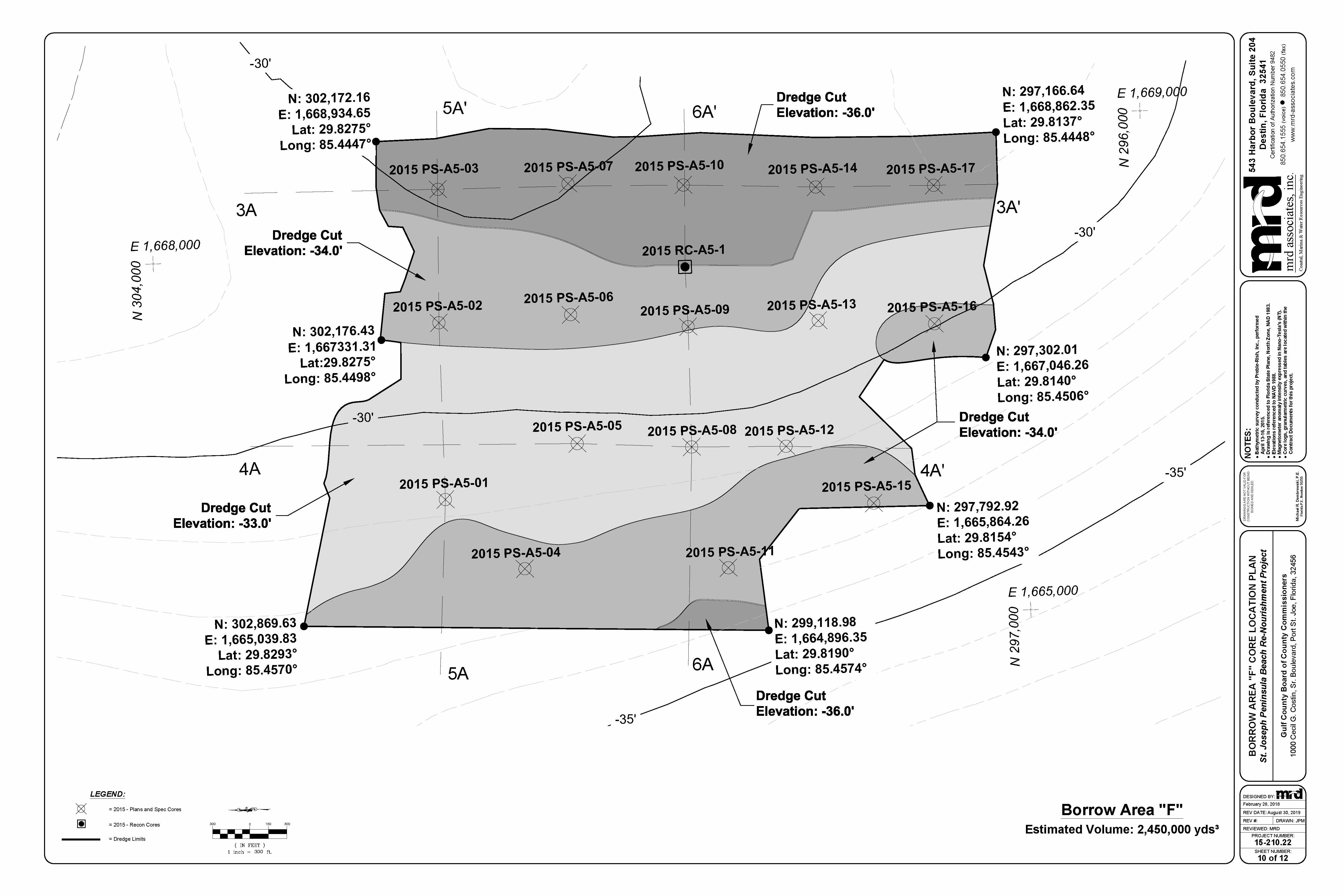
The 2008/2009 restoration project was constructed between R-69 (R-67 with taper) to R-105 (R-105.5 with taper) with approximately 3.6 million cubic yards of beach compatible sand obtained from an offshore borrow area(s). The 7.5 mile restoration project consisted of two segments: 1) the 5.9 mile County Beach Segment (R-74.8 to R-105.5); and, 2) the 1.6 mile State Park Beach Segment (R-74.8 to R-67) within the St. Joseph Peninsula State Park. Borrow Areas “A” and “C” were excavated to supply the project. The Proposed 2017/2018 renourishment project consists of two segments: 1) R-74.8 to R-85.5 (2.1 miles); and, 2) R-89.6 to R-105.5 (3.1 miles). The design is based on the volume losses measured between the end of construction in 2008/2009 and August 2014. This renourishment project will utilize a new borrow area, BA "F" located offshore of the northern portion of the peninsula.
Frequently Asked Questions
Project Construction
Frequently Asked Questions
Construction Easements
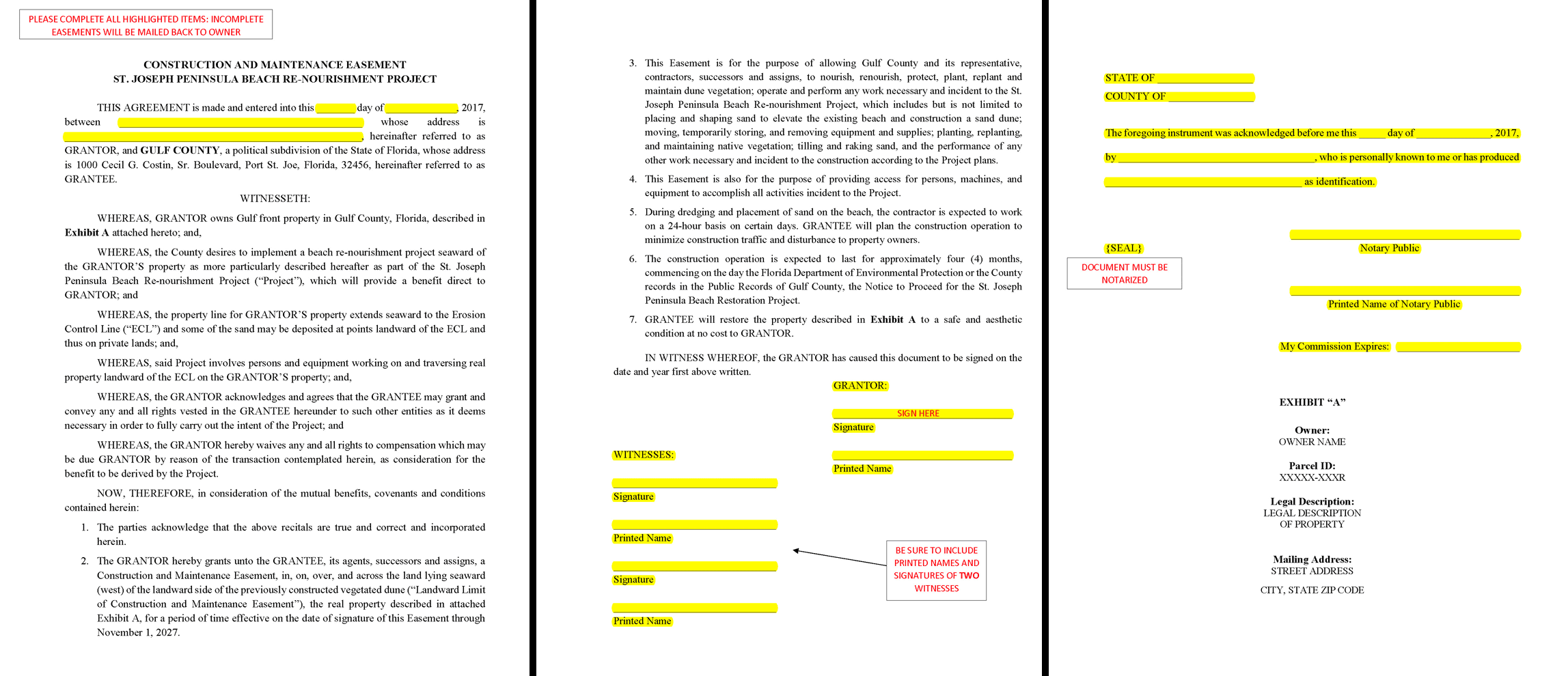
Construction Easement Map
Shown below is a web map that allows you to see your property in relation to the Erosion Control Line (ECL) and the expected landward limits of the Construction Easement. Additionally, you may follow this link to view it in a larger format (*Link takes you to www.arcgis.com). Please note, greater detail is provided as you zoom in towards your property.
*Disclaimer: This map is a public resource of general information. MRD Associates, Inc or Gulf County makes no warranty, representation or guaranty as to the content, sequence, accuracy, timeliness or completeness of any of the database information provided herein. The reader should not rely on the data provided herein for any reason. Map information is believed to be accurate but accuracy is not guaranteed, and the information contained within this map is NOT to be construed or used as a "legal description". In no event will MRD Associates, Inc. or Gulf County be held liable for any damages, including loss of data, lost profits, business interruption, loss of business information or other pecuniary loss that might arise from the use of this mapping service or the information it contains.
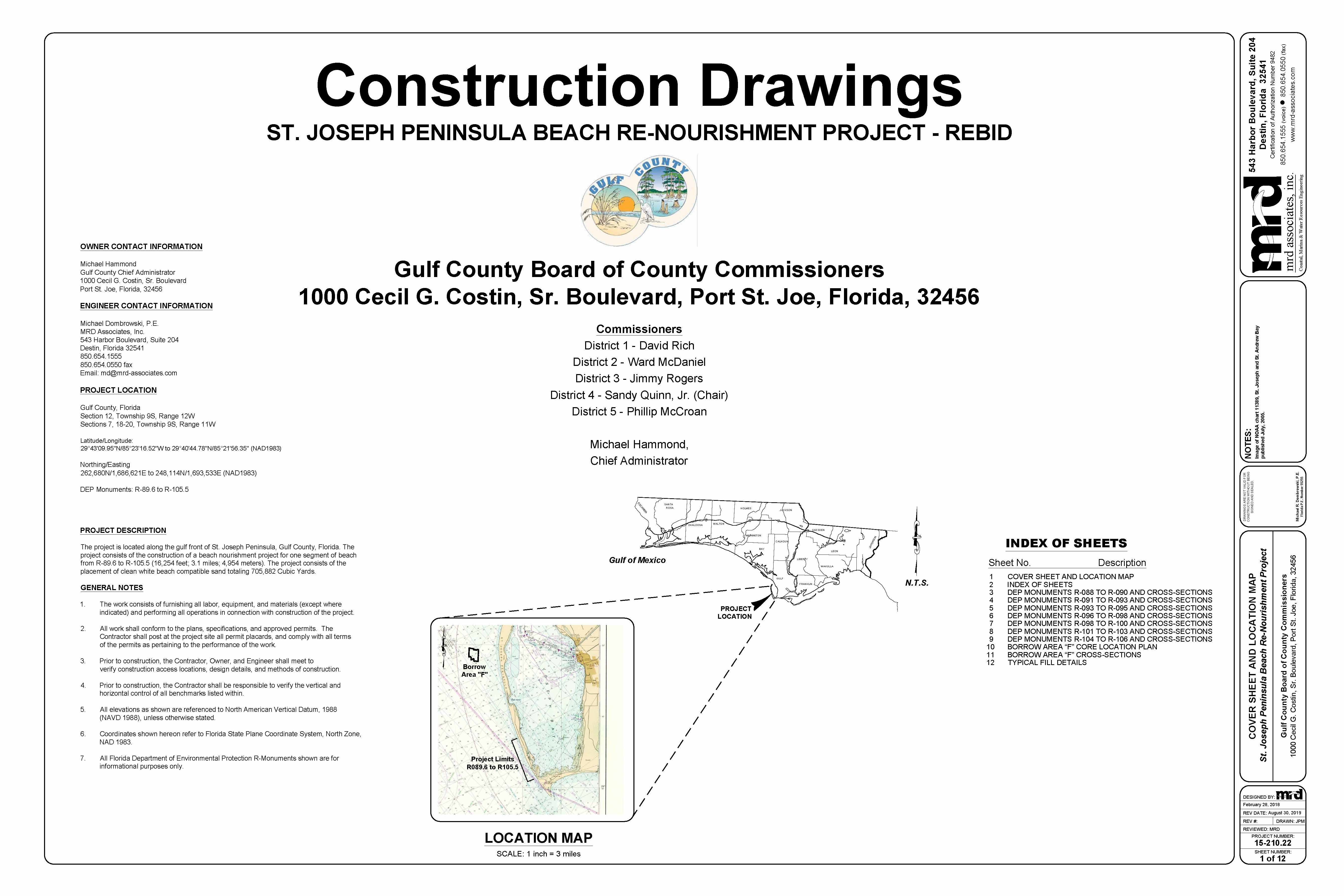
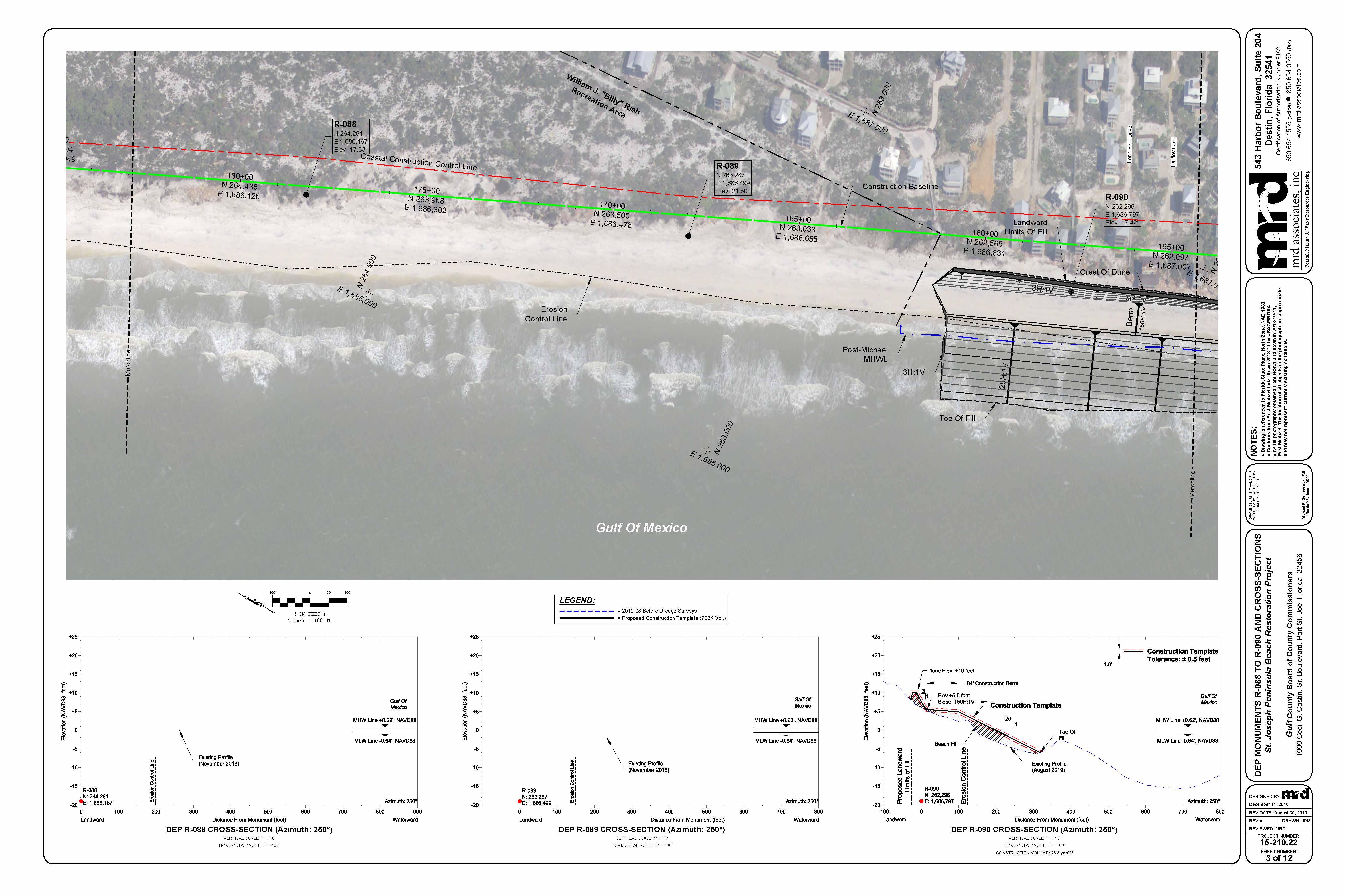
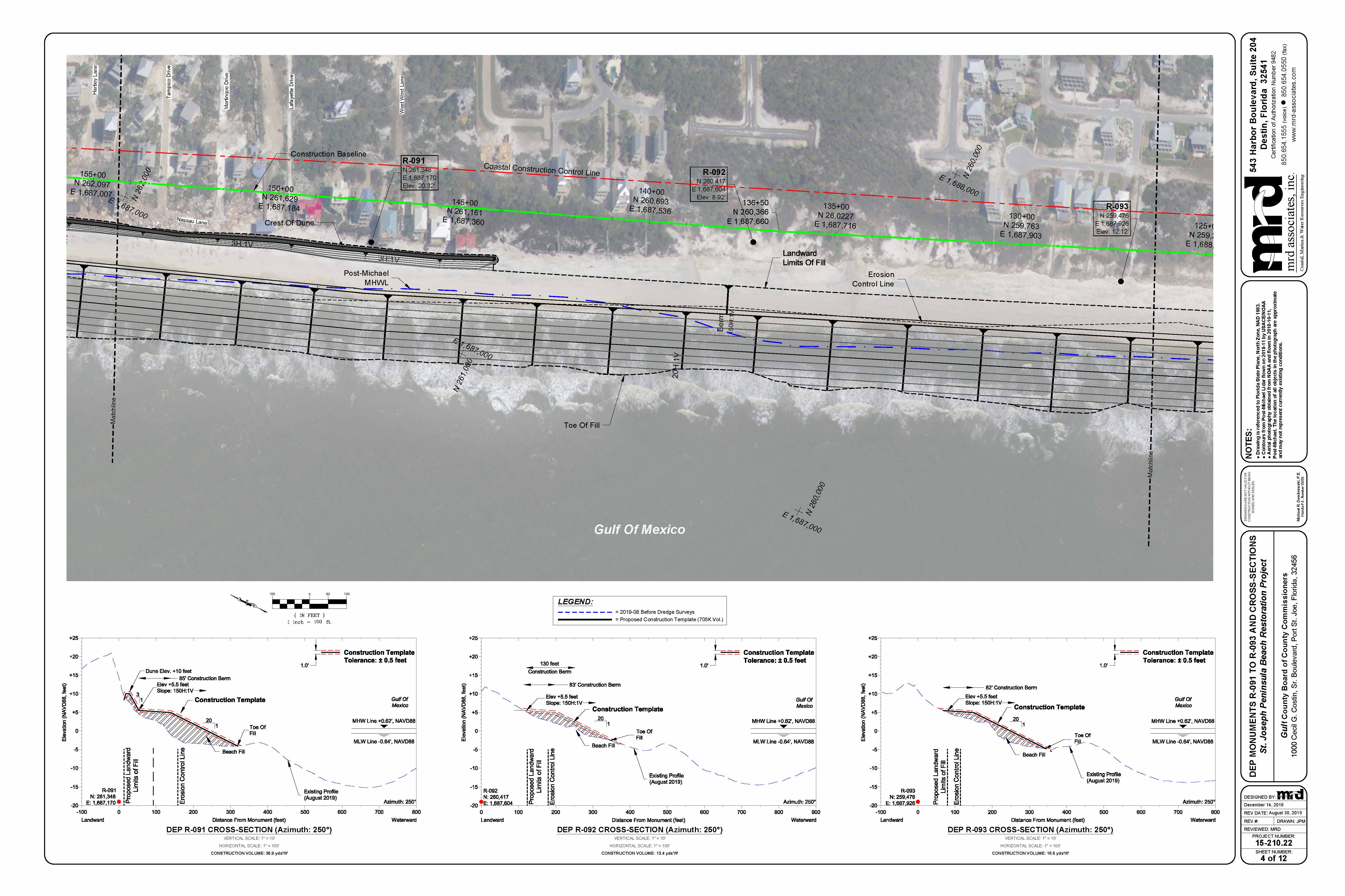
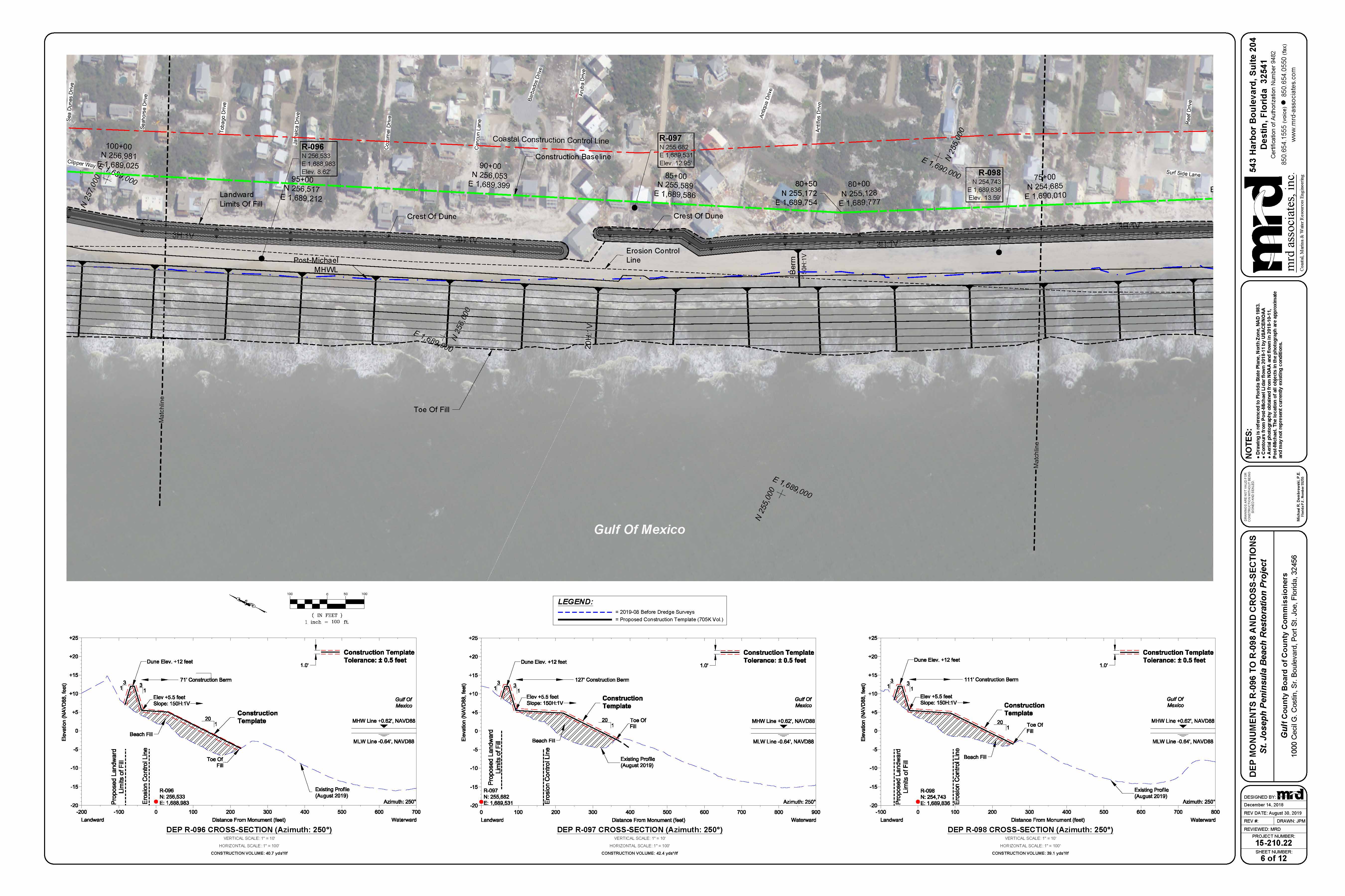
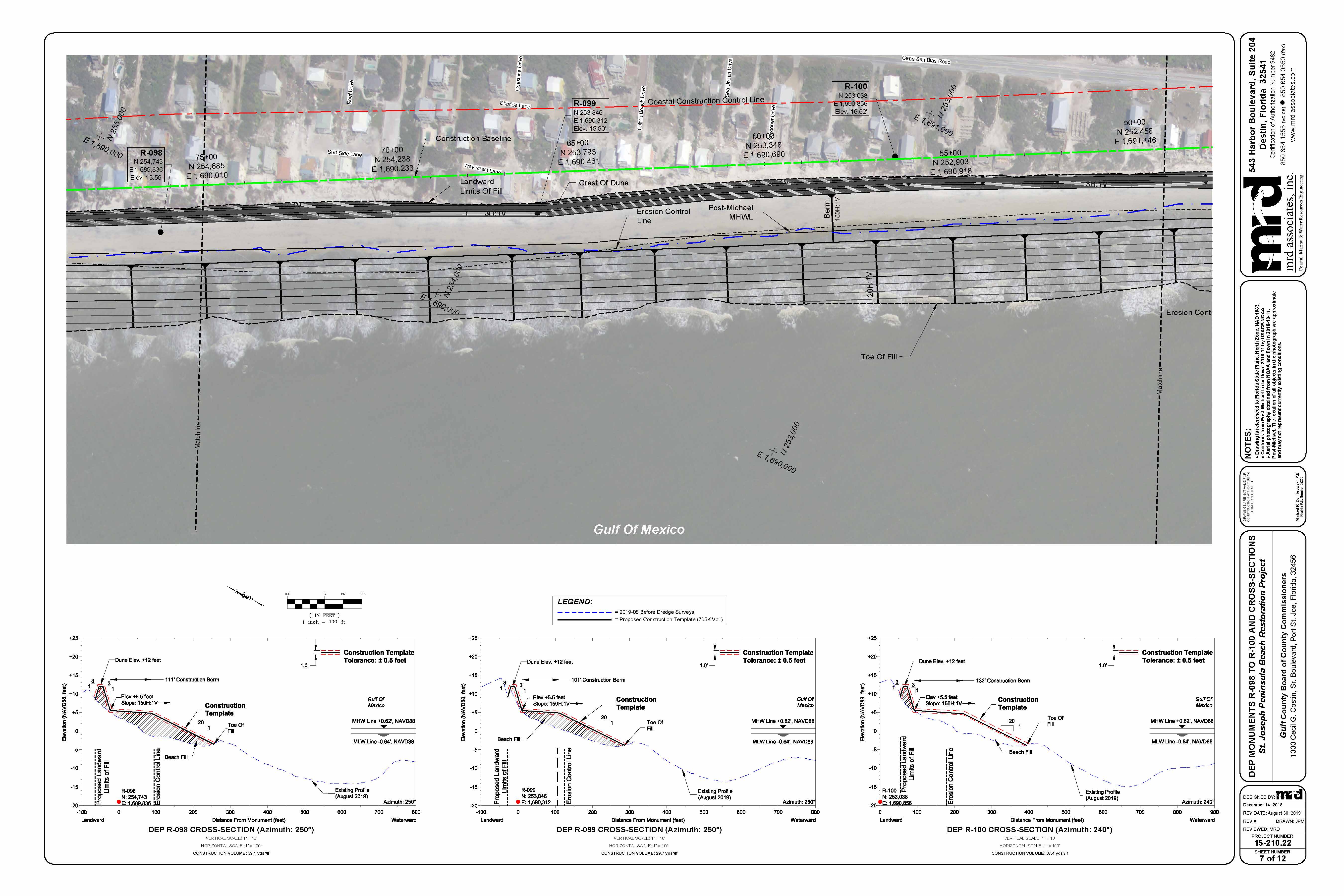
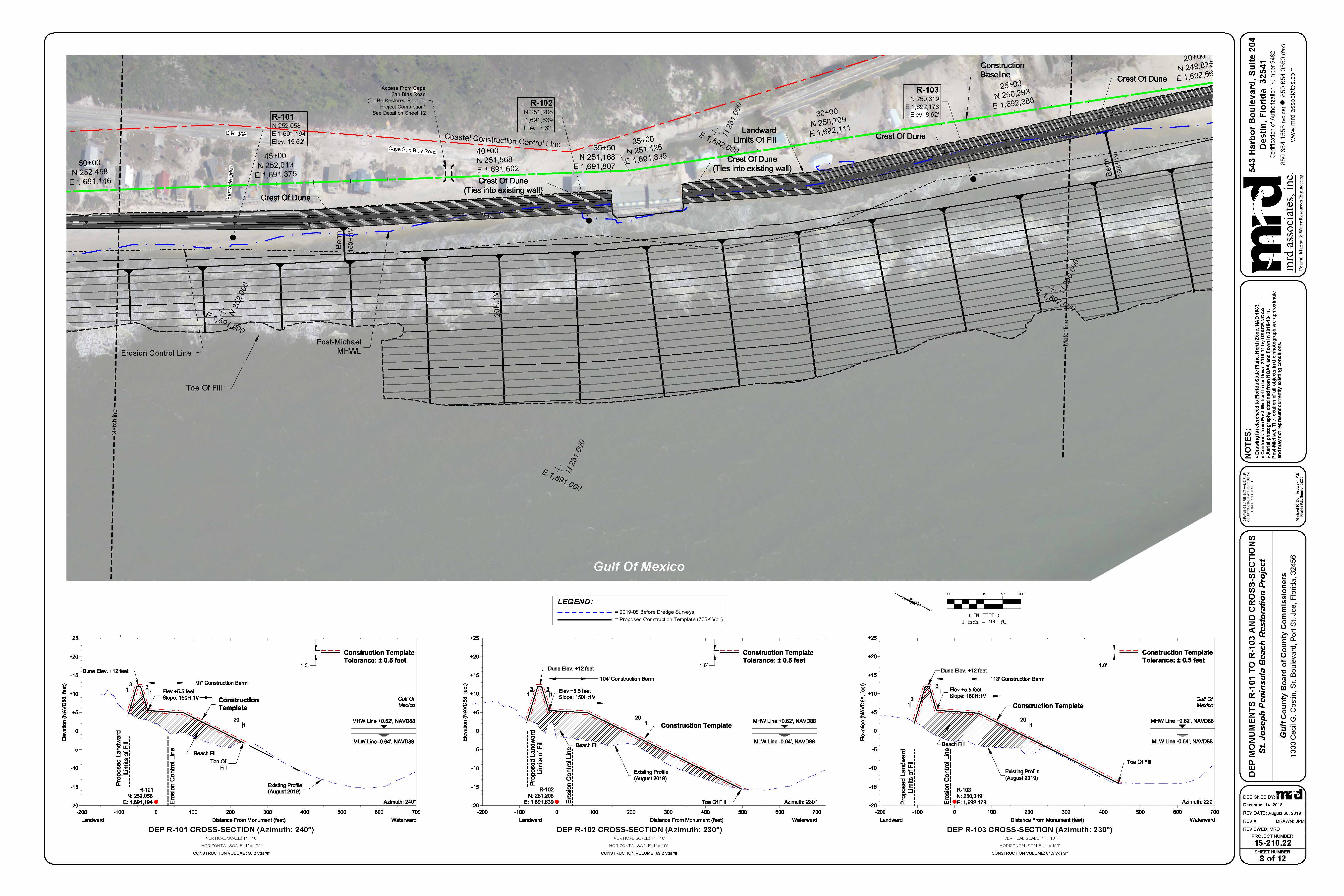
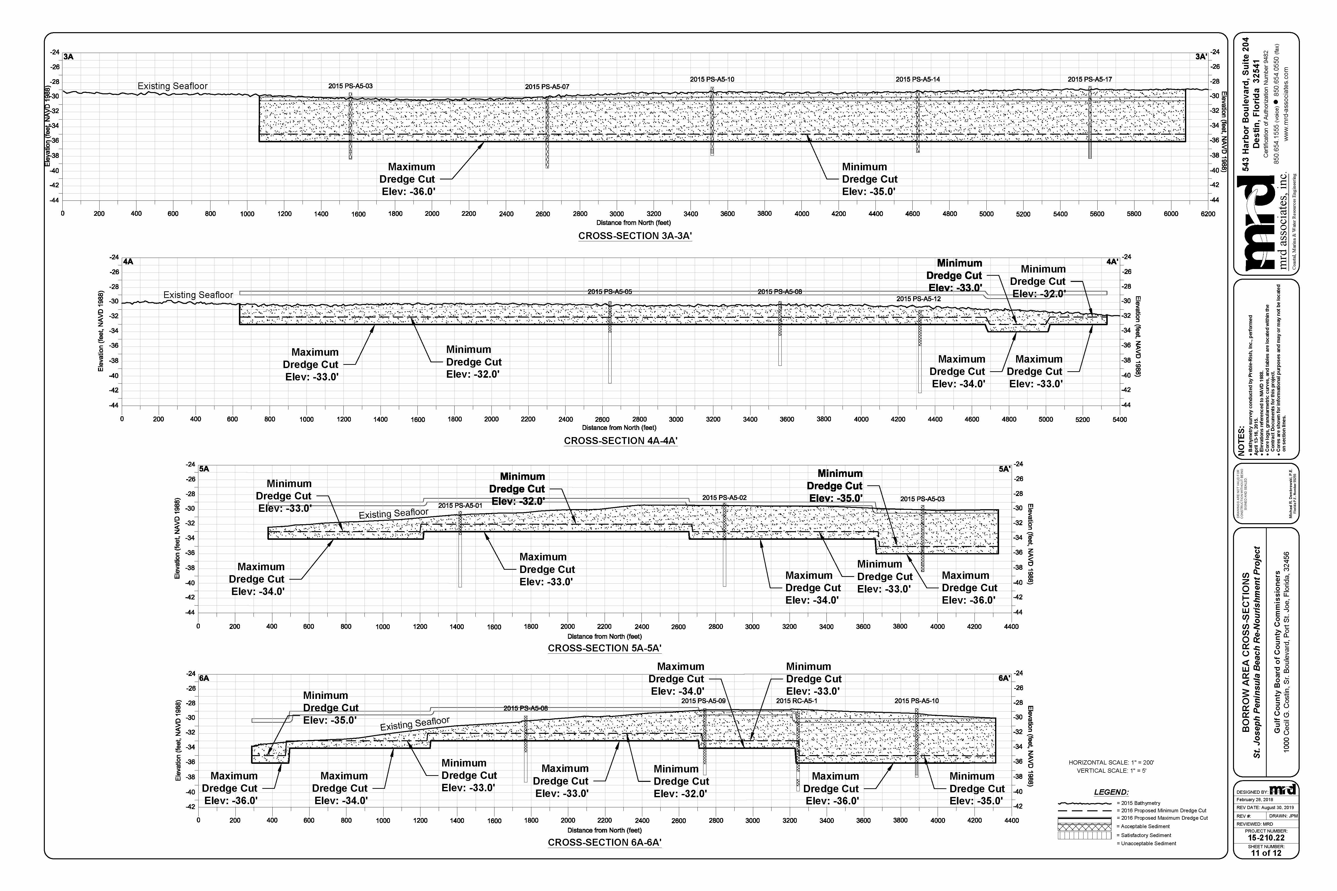
Construction Drawings For the 2019 Beach Renourishment Project
Provided below are images of the plans that will be utilized for Construction. The plans provide details as to the proposed widths and profile shape along the proposed project. Please note the provided plans are not valid for construction without being signed and sealed and are being provided for review only.
Contact Us
If you have a specific question not addressed in the FAQ's, please feel free to send us a message. Typcial response times are between 24 and 48 hours during business hours.